The Indus River and the Makran desert, looking south-southeast from space

Source: http://www.cosmiverse.com/reflib/Image_Gallery/earth/earth127.html
(downloaded June 2001)

Image 127 of 196, Pakistan Pan-Indus River Delta. Credit: NASA Earthrise.

"Two major physiographic features appear in this south-southeast-looking, high-oblique photograph of southern Pakistan--the Indus River and its floodplain and the southeastern end of the complex Makran Mountain Range. The Indus River and its highly cultivated floodplain produce a variety of grain crops and cotton. Annual rainfall varies from year to year and usually does not exceed 20 inches (50 centimeters); therefore, Pakistan, like Egypt with its Nile River, depends on the Indus River for water.

The dark Indus River floodplain is bordered on the east by the Thar Desert (Great Indian Desert) and the highly reflective (white) area in India known as the Great Rann of Kutch (large salt marsh); on the west it is bordered by the complex, folded Makran Mountain Range. Karachi (with an estimated 1990 population of almost 10 million), the major port city on the Arabian Sea and former capital, is located along the western edge of the Indus River floodplain. The large peninsula southeast of the mouths of the Indus River is the Kathiawar Peninsula of India, the home of the only remaining Asian lions."


Looking north from Karachi by satellite and seeing the Makran Range

Source: http://www.jsc.nasa.gov/pao/asiapac/pakistan.html
(downloaded June 2001)

"Makran Range of Pakistan. Photo ID: STS002-09-473. A spectacular view of the Makran Range of Pakistan (27.0N, 65.5E) looking north with the Arabian Sea and the city of Karachi in the foreground. In the center, the Indian sub-continent moving slowly north into the Asian continent has caused the folded sedimentary Makran Range to bend from east-west to north-south as well as the uplift forming The Great Himalaya Range and the high Tibetan Plateau to the north."


A modern landscape: rocks, and the Makran Highway

Source: http://www.flickr.com/photo_zoom.gne?id=57485052&size=o
(downloaded Sept. 2006)


*"Karachi 244 kilometers" on the Makran Highway*

Source: http://www.flickr.com/photo_zoom.gne?id=78815577&size=o
(downloaded Sept. 2006)


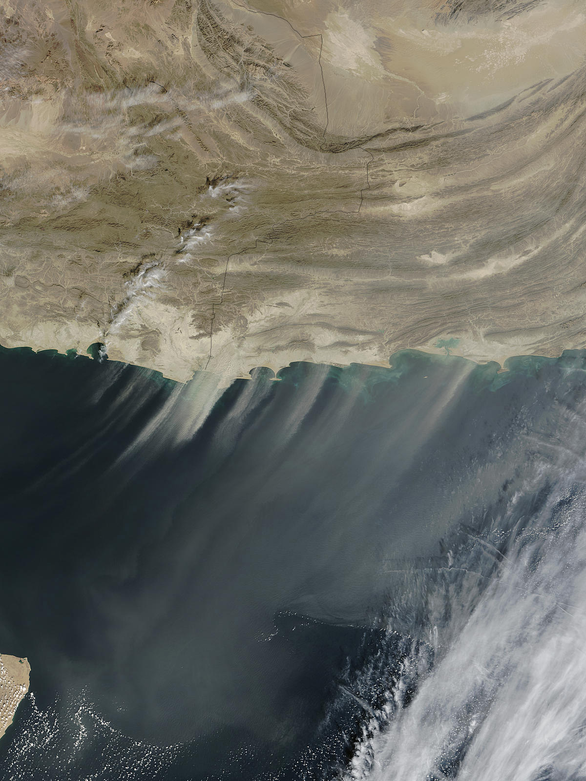
A dust storm in the Makran area, on the Iran/Pakistan border (Nov. 24, 2003)

Source: http://earthobservatory.nasa.gov/NaturalHazards/natural_hazards_v2.php3?img_id=11856
(downloaded Nov. 2004)

"A large storm is blowing thick plumes of desert dust over the Arabian Sea. The dust is coming from the shores of Pakistan (right) and Iran (left). The pattern seen in this image is common. Winds often blow down from Makran Coast Range in Western Pakistan and Eastern Iran into the coastal valleys, and carry dust out over the Sea."


Source: http://www.dawn.com/2001/03/26/local13.htm
(downloaded June 2001)

DAWN (Karachi), March 26, 2001


MAKRAN: Woes that afflict Makran division

 by Aziz Sanghur
 

MAKRAN, March 23: The people of the Makran division have been facing numerous problems such as non-availability of potable water, lack of schools and colleges, absence of healthcare centres and hospitals plus non-existence of a network of roads essential for movement of people and their goods, according to a survey conducted by Dawn.

Makran was once a state of the defunct Balochistan State Union (BSC) from 1947 to October 1955. From October 1955 to July 1970 it was a district of the former West Pakistan and from July 1977 it was a district of the Balochistan province, with its headquarters at Turbat. Makran attained the status of a full-fledged division in July 1977. The Makran division was divided into three districts of Turbat, Punjgur and Gwadar. The town of Gwadar was ceded by the Sultan of Muscat to Pakistan in October 1958. The people of the Makran division are forced to live in miserable conditions by the civic agencies, including the health department, education department, public health engineering department, Wapda, local bodies and B & R.

The few schools and colleges they have are short of teachers and other educational facilities. Thus students, specially girls, are not able to carry on their studies after doing matriculation. So, the literacy rate in this division is very low, about six per cent. Unless the education department comes forward in a big way and increases the facilities, there's every chance that whatever remains of the facilities would wither away in the course of time.

Also, vocational training centres should be established for the local community so that new skills can be learnt. This is necessary for development.

Another count on which the people suffer greatly is the absence of a network of metalled roads. The kutcha tracks that are there are no less than a nightmare for anyone who travels on these bumpy pathways. A very few of them are motorable and that too in fair weather only. The poor network of communication has held up the development of the division so long.

The division can immediately be launched into a development process provided serious efforts are made to quickly build up a network of communication consisting of metalled roads, highways, railways and bridges that should facilitate the movement of both people and their merchandise and provide them access to the coastline. It would instantly boost trade activities.

At present the main roads are Gwadar-Turbat via Talar, Gwadar-Pasni-Turbat, Gwadar-Mand-Turbat, Gwadar-Pasni-Ormara-Karachi. Most of these road-links are dirt tracks and unmetalled. All-weather access roads in the coastal area will go a long way towards uplifting coastal communities, increasing trade and commerce, creating employment, etc. However, environment must be protected as unplanned development might endanger natural resources by increased pollution and population pressure.

Because of lack of health facilities, the people have to travel to Karachi for treatment but there they cannot afford to pay high fees charged by private hospitals and clinics. About 50 per cent of BHUs (basic health units) and hospitals in the division have been facing acute shortage of doctors and medicines, causing hardship for the people.

One of the most basic needs of man - water - is not available to the people easily. Particularly the potable water is very, very hard to come by. Women, children and some time men have to travel long distances to get a pail of water, and that too from a pond or a well. Strictly speaking, this pond or well water, in most cases, is not fit for human consumption. Although human thirst is quenched for a moment or man's immediate need is fulfilled by the pond water, over the period it acts with a vengeance, it costs the health of those who use it. Its consumption leads to various diseases.

The administration knows the problems fully well, some of which, according to the people, can be resolved with a little effort but no one seems to have any time for the betterment of the Makran division.

All hue and cry by political and social workers has fallen on deaf ears.

Federal minister Zubeida Jalal belongs to the Makran division and knows all about its problems, but the people say she has not yet shown any inclination to resolve these.


== Indian Routes index == Indian Routes sitemap == Glossary == FWP's main page ==